
This blog post is part of a series:
- Visualizing Data with ClickHouse - Part 1 - Grafana
- Visualizing Data with ClickHouse - Part 2 - Superset
Introduction
In this post, we continue our series on the visualization of data in Clickhouse[1][2] by exploring Metabase as a popular tool for less technical business users.
Metabase
Metabase offers a simpler experience for those less comfortable with writing SQL. Queries can be constructed by simply dragging and dropping fields - a feature likely to appeal to business users. Focusing on fast data exploration, the breadth of visuals and customizability is less than previous tools we’ve demonstrated, with the benefit of a cleaner and simpler interface and workflow.
Downloading the Metabase jar offers the simplest getting-started experience. This requires you to have a Java Runtime Environment (JRE) installed on your system. Ensure you download the ClickHouse driver (jar file), placing this in a “/plugins” subdirectory. Starting Metabase is then trivial:
java -jar metabase.jarThe app can take a few minutes to start. The console should redirect you to http://localhost:3000 once Metabase is ready.
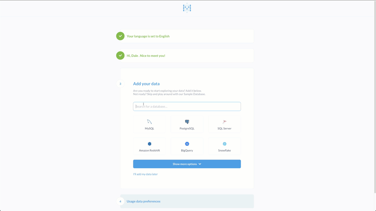
Select ClickHouse as your database during setup and assign a name to the data source. Note the usage of the HTTP port.
Metabase offers an exploration feature useful for obtaining a quick overview of a particular dataset. The overview statistics such as field cardinality and value changes over time. Below we explore the forex dataset, from an earlier post, to obtain an overview of the main base and quote columns.
Users of Metabase create analytics that can be based on either traditional SQL queries or a “question”. Questions are built with a guided query builder where the user selects a database, table, filter, and summarization field. The summarization can also be split into groups - effectively using a GROUP BY. This intuitive approach allows users to build simple visualizations quickly.
Below we use the question feature to view the average price for the EUR currency pairs USD, AUD, CAD, CHF, GPB, and NZD from our forex dataset. Note we assume the bid price represents the average price of the currency pair.
This “question” approach is particularly suited to most simple visualization requirements. For more complex visualizations, Metabase offers a SQL editor. The user simply has to ensure results are returned in a structure appropriate to visualize - similar to the Grafana approach. With no client-side transformation logic, all manipulation is deferred to the query itself. With an extensive range of analytical functions, this suits ClickHouse and is typically encouraged even for the largest datasets.
Below we demonstrate using this SQL editor to show the world’s coldest countries, according to our NOAA dataset, overlaid on a regional map.
SELECT code, min(tempMin) / 10 AS min_temp FROM blogs.noaa WHERE date > '1970-01-01' GROUP BY substring(station_id, 1, 2) AS code LIMIT 1000✎
As well as region maps, Metabase includes a Grid map. While currently quite simple, this can be useful for plotting points where the color intensity is determined by a metric. We use this capability to plot weather events in the United States where the wind gust speed was greater than 100 kph or approx. 30 MPS (our units of wind gust speed are tenths of meters per second), and significant volumes of rain were involved over the period of a week, i.e., more than 2cm of rain on average per day. We restrict this to the period of July to October, which loosely describes the conditions and time of year for hurricanes. We finally plot the top 2 highest events per year with respect to wind speed and filter out events of high elevation (>500m) - as bad weather tends to be a common occurrence on mountain peaks! Note the use of the function geohashEncode to capture significant events over a wide area, rather than potentially single anomalous stations, as well as the dictGet function to restrict our analysis to the United States.
As expected, we capture hurricanes impacting the east coast - including Katrina in 2005.
SELECT week, toYear(week) AS year, lat, lon, avg_precipitation, max_wind_speed * 10 FROM ( SELECT geoHash, week, geohashDecode(geoHash) AS lonlat, lonlat.1 AS lon, lonlat.2 AS lat, max(maxWindSpeed) AS max_wind_speed, avg(precipitation)/10 AS avg_precipitation FROM blogs.noaa WHERE (dictGet(blogs.country_polygons, 'name', location) IN ('United States of America')) AND (elevation < 500) AND toMonth(date) BETWEEN 6 AND 10 GROUP BY geohashEncode(location.1, location.2, 4) AS geoHash, toStartOfWeek(date) AS week HAVING max_wind_speed > 300 AND avg_precipitation > 20 ORDER BY max_wind_speed DESC ) ORDER BY year ASC, max_wind_speed DESC LIMIT 2 BY year✎
The waterfall visualization conveys similar information to the Grafana candlestick shown in our earlier post - a popular technique for forex datasets. Below we reuse a query from our earlier forex post to plot the GBP/EUR currency pair change - using a window function over the daily close price. As shown, Metabase also preserves the notion of dashboards to collate multiple visualizations.
SELECT base, quote, day, close, close - any(close) OVER (PARTITION BY base, quote ORDER BY base ASC, quote ASC, day ASC ROWS BETWEEN 1 PRECEDING AND CURRENT ROW) AS change FROM ( SELECT base, quote, day, argMax(ask, datetime) AS close FROM blogs.forex WHERE (quote = 'GBP') AND (base = 'EUR') GROUP BY base, quote, toStartOfDay(datetime) AS day ORDER BY base ASC, quote ASC, day ASC ) ORDER BY day ASC✎
Similar to Grafana and Superset, Metabase supports combo charts to allow multiple axes to be plotted. For example purposes, we use the UK house price dataset used throughout our docs. We plot the average house price and sales per month since 1995, differentiating between leasehold and freehold transactions.

SELECT month, countIf(duration = 'leasehold') AS `Leasehold Sold`, countIf(duration = 'freehold') AS `Freehold Sold`, avgIf(price, duration = 'freehold') AS `Average Freehold Price`, avgIf(price, duration = 'leasehold') AS `Average Leasehold Price` FROM uk_price_paid GROUP BY toStartOfMonth(date) AS month ORDER BY month ASC✎
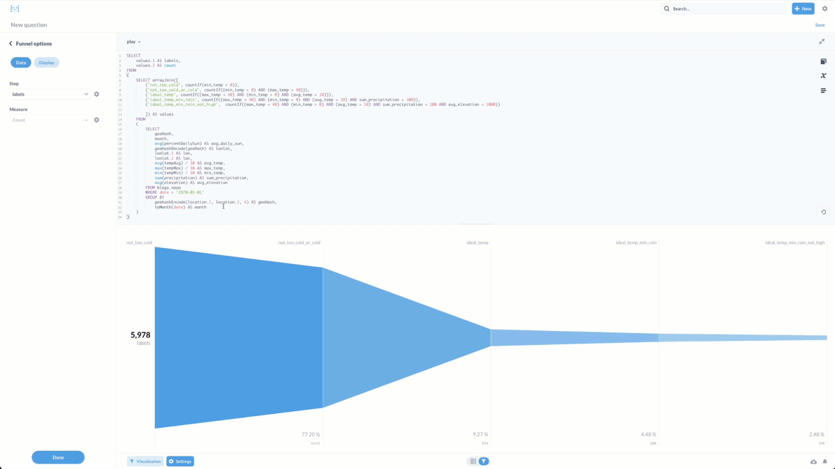
Returning to our NOAA dataset, we were curious as to where might be perfect holiday destination based on climatic conditions. Our rudimentary criteria - good temperature range, little rain, non-excessive elevation, and absence of extreme weather events, might be a little contrived, but this allows us to demonstrate the funnel visualization and usage of the arrayJoin and If combinator functions for transforming column names to values. We compute our conditions over geo hash regions and months of the year, thereby not just considering a single station recording.
SELECT values.1 AS labels, values.2 AS count FROM ( SELECT arrayJoin([('not_too_cold', countIf(min_temp > 0)), ('not_too_cold_or_cold', countIf((min_temp > 0) AND (max_temp < 40))), ('ideal_temp', countIf((max_temp < 40) AND (min_temp > 0) AND (avg_temp > 10))), ('ideal_temp_min_rain', countIf((max_temp < 40) AND (min_temp > 0) AND (avg_temp > 10) AND (sum_precipitation < 100))), ('ideal_temp_min_rain_not_high', countIf((max_temp < 40) AND (min_temp > 0) AND (avg_temp > 10) AND (sum_precipitation < 100) AND (avg_elevation < 1000)))]) AS values FROM ( SELECT geoHash, month, avg(percentDailySun) AS avg_daily_sun, geohashDecode(geoHash) AS lonlat, lonlat.1 AS lat, lonlat.2 AS lon, avg(tempAvg) / 10 AS avg_temp, max(tempMax) / 10 AS max_temp, min(tempMin) / 10 AS min_temp, sum(precipitation) AS sum_precipitation, avg(elevation) AS avg_elevation FROM blogs.noaa WHERE date > '1970-01-01' GROUP BY geohashEncode(location.1, location.2, 4) AS geoHash, toMonth(date) AS month ) )✎
For those curious about the optimal locations, the Pin map allows us to interpret the coordinates quickly. This requires us to move our most restrictive condition to a HAVING clause.
SELECT geoHash, month, avg(percentDailySun) AS avg_daily_sun, geohashDecode(geoHash) AS lonlat, lonlat.1 AS lon, lonlat.2 AS lat, avg(tempAvg) / 10 AS avg_temp, max(tempMax) / 10 AS max_temp, min(tempMin) / 10 AS min_temp, sum(precipitation) AS sum_precipitation, avg(elevation) AS avg_elevation FROM blogs.noaa WHERE date > '1970-01-01' GROUP BY geohashEncode(location.1, location.2, 4) AS geoHash, toMonth(date) AS month HAVING (max_temp < 40) AND (min_temp > 0) AND (avg_temp > 10) AND (sum_precipitation < 100) AND (avg_elevation < 1000)✎
We’ll leave it to the reader to explore these locations and report if they do make ideal holiday destinations.
Summary
In this post, we’ve demonstrated how Metabase offers a great getting-started experience for users not familiar with SQL by providing a simple but effective way to build visualizations for BI via the questions feature. This contrasts with the other tools in this blog series which address other needs. Grafana has a clear strength with respect to time series data and its evolving flexibility in use cases such as geo analysis, requiring users to be comfortable in SQL. Superset meanwhile optimizes for data analysts and BI use cases with an excellent SQL editor and the ability to save any query as a reusable “dataset”, resulting in a highly effective way of building visualizations. Your choice will often depend on your data and personal preference, but all are first-class citizens within the ClickHouse ecosystem, which we hope to continue to improve.
If you’re enthusiastic about the latest technologies and are passionate about Open Source, we’re currently hiring for our integrations team and would love to hear from you.


